![](/images/other/stat-length.png)
![Excursión A pie Bayerisch Eisenstein - Linde - Photo](https://media.geolcdn.com/t/1900/400/ext.pjpeg?maxdim=2&url=https%3A%2F%2Fmedia.geolcdn.com%2Ff%2F0c6e5d1b-035e-4552-9e7a-f27698aeafe3.jpeg)
Linde
SityTrail - itinéraires balisés pédestres
Tous les sentiers balisés d’Europe PRO
![Longitud](/images/other/stat-length.png)
Longitud
8,8 km
![Altitud máxima](https://static1.geolcdn.com/siteimages/upload/files/1508320355ic_sort_altitude_max_24dp.png)
Altitud máxima
799 m
![Desnivel positivo](https://static1.geolcdn.com/siteimages/upload/files/1508320355ic_sort_den_pos_24dp.png)
Desnivel positivo
156 m
![Km-Effort](/images/other/stat-length.png)
Km-Effort
11,1 km
![Altitud mínima](https://static1.geolcdn.com/siteimages/upload/files/1508320355ic_sort_altitude_min_24dp.png)
Altitud mínima
627 m
![Desnivel negativo](https://static1.geolcdn.com/siteimages/upload/files/1508320355ic_sort_den_neg_24dp.png)
Desnivel negativo
229 m
![Boucle](https://static1.geolcdn.com/siteimages/upload/files/16400158638029165_repeat_loop_refresh_sync_direction_icon.png)
Boucle
No
Baliza
Fecha de creación :
2022-02-11 13:04:09.719
Última modificación :
2022-02-11 13:04:09.719
![A pie](https://static1.geolcdn.com/sitytour/trail-icons/100.png)
2h31
Dificultad : Fácil
![Escanee este código QR para abrir la excursión en la aplicación SityTrail](https://capi.geolives.com/qq0zvz2zws4bq2lad0pu/sitytour/trails/3089069/qr.png?size=200)
Aplicación GPS de excursión GRATIS
A propósito
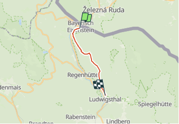
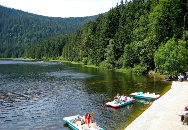
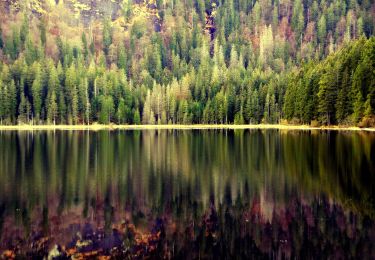
Ruta A pie de 8,8 km a descubrir en Baviera, Landkreis Regen, Bayerisch Eisenstein. Esta ruta ha sido propuesta por SityTrail - itinéraires balisés pédestres.
Descripción
Trail created by Nationalpark Bayerischer Wald.
Symbol: Pflanzensymbol (Linde) in schwarz auf weißem quadratischem Grund
Localización
País:
Germany
Región :
Baviera
Departamento/provincia :
Landkreis Regen
Municipio :
Bayerisch Eisenstein
Localidad:
Unknown
Salida:(Dec)
Salida:(UTM)
368795 ; 5442400 (33U) N.
Comentarios
Excursiones cerca
![Excursión A pie Bayerisch Eisenstein - 9 Bodenmais - Arbersee - Photo](https://media.geolcdn.com/t/375/260/ext.jpg?maxdim=2&url=https%3A%2F%2Fmedia.geolcdn.com%2Ff%2Ff56e1f52-8d0e-4417-b0a5-1422cf04f446.jpeg)
![A pie A pie](https://static1.geolcdn.com/sitytour/trail-icons/100.png)
9 Bodenmais - Arbersee
A pie
Fácil
Bayerisch Eisenstein,
Baviera,
Landkreis Regen,
Germany
![](/images/other/stat-length.png)
6,5 km | 10 km-effort
2h 16min
![](https://static1.geolcdn.com/siteimages/upload/files/16400158638029165_repeat_loop_refresh_sync_direction_icon.png)
No
![Excursión A pie Bayerisch Eisenstein - 8 Bayerisch Eisenstein - Großer Arbersee - Photo](https://media.geolcdn.com/t/375/260/ext.jpg?maxdim=2&url=https%3A%2F%2Fmedia.geolcdn.com%2Ff%2Fd0ad27a5-19cf-4384-84d1-490fa1643a69.jpeg)
![A pie A pie](https://static1.geolcdn.com/sitytour/trail-icons/100.png)
8 Bayerisch Eisenstein - Großer Arbersee
A pie
Fácil
Bayerisch Eisenstein,
Baviera,
Landkreis Regen,
Germany
![](/images/other/stat-length.png)
5,1 km | 7,8 km-effort
1h 46min
![](https://static1.geolcdn.com/siteimages/upload/files/16400158638029165_repeat_loop_refresh_sync_direction_icon.png)
No
![Excursión A pie Bayerisch Eisenstein - Waldmaus - Photo](https://media.geolcdn.com/t/375/260/ext.jpg?maxdim=2&url=https%3A%2F%2Fmedia.geolcdn.com%2Ff%2Fec564ee6-9a22-41c5-a04e-8696a383aab7.jpeg)
![A pie A pie](https://static1.geolcdn.com/sitytour/trail-icons/100.png)
Waldmaus
A pie
Fácil
Bayerisch Eisenstein,
Baviera,
Landkreis Regen,
Germany
![](/images/other/stat-length.png)
3,4 km | 5,7 km-effort
1h 17min
![](https://static1.geolcdn.com/siteimages/upload/files/16400158638029165_repeat_loop_refresh_sync_direction_icon.png)
Sí
![Excursión A pie Bayerisch Eisenstein - Bussard - Photo](https://media.geolcdn.com/t/375/260/ext.jpg?maxdim=2&url=https%3A%2F%2Fmedia.geolcdn.com%2Ff%2F909ef040-56c7-48d9-a356-ecebf9ed9a65.jpeg)
![A pie A pie](https://static1.geolcdn.com/sitytour/trail-icons/100.png)
Bussard
A pie
Fácil
Bayerisch Eisenstein,
Baviera,
Landkreis Regen,
Germany
![](/images/other/stat-length.png)
7,9 km | 11,9 km-effort
2h 42min
![](https://static1.geolcdn.com/siteimages/upload/files/16400158638029165_repeat_loop_refresh_sync_direction_icon.png)
Sí
![Excursión A pie Lindberg - Ameise - Photo](https://media.geolcdn.com/t/375/260/ext.jpg?maxdim=2&url=https%3A%2F%2Fmedia.geolcdn.com%2Ff%2F2611658f-a6d2-422c-8a2f-e070abc64b73.jpeg)
![A pie A pie](https://static1.geolcdn.com/sitytour/trail-icons/100.png)
![Excursión A pie Lindberg - Siebenschläfer - Photo](https://media.geolcdn.com/t/375/260/ext.jpg?maxdim=2&url=https%3A%2F%2Fmedia.geolcdn.com%2Ff%2F2611658f-a6d2-422c-8a2f-e070abc64b73.jpeg)
![A pie A pie](https://static1.geolcdn.com/sitytour/trail-icons/100.png)
Siebenschläfer
A pie
Fácil
Lindberg,
Baviera,
Landkreis Regen,
Germany
![](/images/other/stat-length.png)
7,3 km | 9,9 km-effort
2h 14min
![](https://static1.geolcdn.com/siteimages/upload/files/16400158638029165_repeat_loop_refresh_sync_direction_icon.png)
Sí
![Excursión A pie Lindberg - Heidelbeere - Photo](https://media.geolcdn.com/t/375/260/ext.jpg?maxdim=2&url=https%3A%2F%2Fmedia.geolcdn.com%2Ff%2F230548f5-1ea7-4949-ba56-957e6fdab64c.jpeg)
![A pie A pie](https://static1.geolcdn.com/sitytour/trail-icons/100.png)
Heidelbeere
A pie
Fácil
Lindberg,
Baviera,
Landkreis Regen,
Germany
![](/images/other/stat-length.png)
8,2 km | 15,5 km-effort
3h 31min
![](https://static1.geolcdn.com/siteimages/upload/files/16400158638029165_repeat_loop_refresh_sync_direction_icon.png)
No
![Excursión A pie Lindberg - Eibe - Photo](https://media.geolcdn.com/t/375/260/ext.jpg?maxdim=2&url=https%3A%2F%2Fmedia.geolcdn.com%2Ff%2F230548f5-1ea7-4949-ba56-957e6fdab64c.jpeg)
![A pie A pie](https://static1.geolcdn.com/sitytour/trail-icons/100.png)
![Excursión A pie Lindberg - Schwarzstorch - Photo](https://media.geolcdn.com/t/375/260/ext.jpg?maxdim=2&url=https%3A%2F%2Fmedia.geolcdn.com%2Ff%2F4a6864fb-cf73-477a-8327-678444bdd300.jpeg)
![A pie A pie](https://static1.geolcdn.com/sitytour/trail-icons/100.png)
Schwarzstorch
A pie
Fácil
Lindberg,
Baviera,
Landkreis Regen,
Germany
![](/images/other/stat-length.png)
3,7 km | 4,9 km-effort
1h 6min
![](https://static1.geolcdn.com/siteimages/upload/files/16400158638029165_repeat_loop_refresh_sync_direction_icon.png)
No